As I write we have brutal heat in Brisbane, with a dry west wind. On 11 January last year Robert Merkel put up a post, Queensland floods get worse. Later that day Mark put up a post, Brisbane flood maps and up to date flood information and slaved mightily for a time passing on information gleaned from twitter and other sources, until he went quiet. By the 12th he was a refugee at my place. His place was high and dry, but the power went off. By the 14th the Brisbane floods were in retreat.
Earlier on the 10th there had been what we used to call a ‘cloudburst’ on the Toowoomba Range, when 150mm (6 inches in the old money) fell in about half an hour. I posted some Toowoomba flood pics taken by my cousin’s brother-in-law. Yesterday I heard Anna Bligh tell the story of a year ago, how she was addressing the umpteenth press briefing on the Queensland floods. From September 2010 there had been many cities and towns flooded across Queensland, some of them totally evacuated several times. As she fronted the media a minder handed her a sheet with breaking news. She found herself talking about swift water rescues in the main street of Toowoomba. “This can’t be right”, she thought. “It’s impossible.” It wasn’t. This is what was going on in Toowoomba:
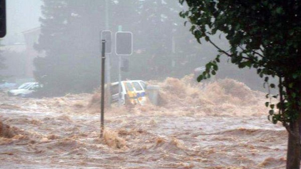
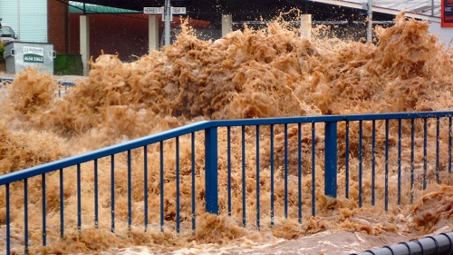
Those photos are from a Toowoomba Chronicle gallery of reader pics.
From memory two people died in the Toowoomba floods. Of course on the eastern escarpment a worse tragedy was unfolding as a tsunami of water was launched onto the small town of Grantham and the Lockyer Valley. People were barely warned when minutes later they were fighting for their lives. Whole houses were washed away. Some people went to the railway bridge for a good view and found themselves running for their lives.
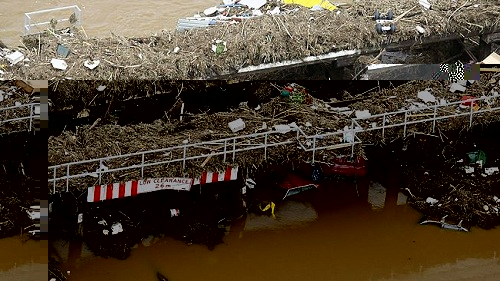
The image comes from this article in The Australian. I picked it up from Google images.
Wikipedia gives an account of the Queensland floods in the various river basins and tells us that as on January 28, 2011 the death toll was 35, 21 from Toowoomba and the Lockyer Valley, with 9 missing. Most of the missing would have been from the Lockyer Valley.
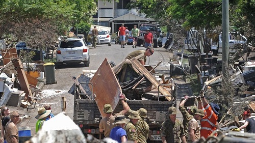
Very soon in Brisbane the big cleanup was underway with a citizens’ army as well as the real one:
Citizen Rudd was there to help:
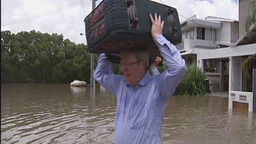
I believe he got an infected foot out of it. Perhaps he wasn’t wearing these:
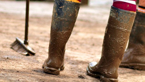
Those pics came from the ABC gallery, the best I’ve seen.
There was a lot of social capital created by the Queensland floods, much of which exists today. Wounds were also created, many still open or thinly covered by scar tissue. A year later it’s a time for looking forward as well as looking back, but we’ve changed forever, and not just those directly involved.
Points along these lines were made at a dawn service and a string of memorial events on 10 January, all attended by Anna Bligh and at least the first by Julia Gillard and Quentin Bryce.
The media were there in force. Here are reports, for example, from
Courier Mail, the ABC and The Age. Perhaps the best was this one in the Toowoomba Chronicle and syndicated through other rural papers.
Today (11th) the caravan moved on to Ipswich and tomorrow it will be Brisbane.
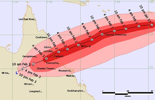
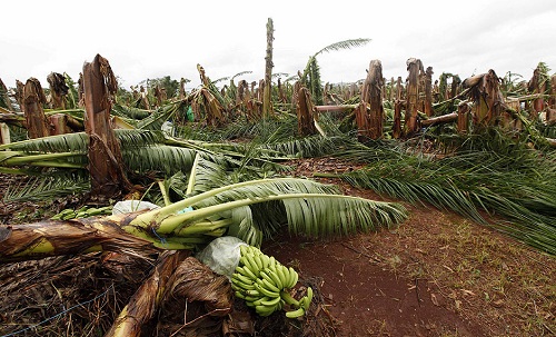
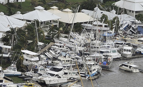
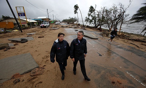
The Brisbane floods were not the end of the matter as far as nature was concerned. At the end of the month Cyclone Yasi came steaming in:
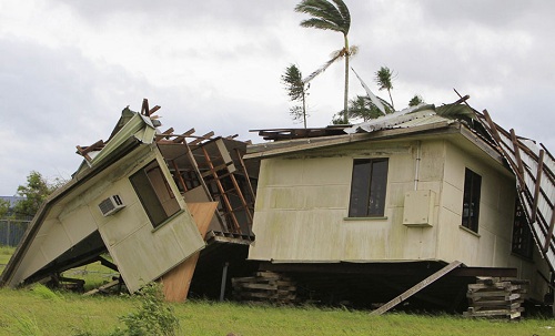
Yasi brought broken houses:
smashed crops:
piled up boats:
and utter devastation in Cardwell:
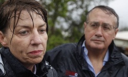
The experience of the summer is written on Premier Bligh’s face:
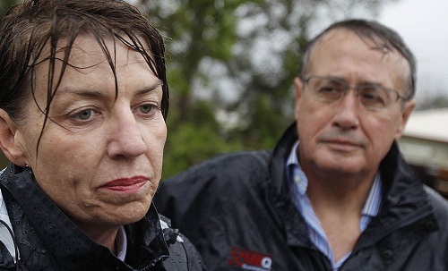
I must admit to shedding a tear or two when finding that one amongst the other images in the Brisbane Times photo gallery.
OK, here are a few links from the media, mainly the ABC and the Courier Mail.
The ABC has a gallery of flood pics contrasting before and during the flood.
The Courier Mail’s gallery contrasts during the flood and a year later.
This CM page has links to specific stories.
The ABC has an interesting account of the role played by twitter.
ABC OPEN has a feature: Aftermath: disaster, resilience and recovery which collects stories from within the community.
Bligh has emphasised the a complete rebuild will take about three years. Here’s a gallery of buildings still under repair.
Property prices have been affected, not always logically.
Here is a list of all our posts on Queensland floods, not all of them already linked above:
Brian on Queensland floods
Robert on Queensland floods get worse
Mark on Brisbane flood maps and up to date flood information
Brian on Toowoomba flood pics
Brian on Brisbane floods in retreat
Kim on Political cheap shots and the Brisbane floods
Kim on Quick link: Quiggin on water policy after the Queensland floods
Kim on Quicklink: Interactive map of Brisbane flood damage
Kim on Germaine Greer wrong on Brisbane floods
Mark on Social capital, social networking and the Brisbane floods
Brian on Open thread on Queensland floods
Brian on Wivenhoe dam management
Brian on Cyclone watch
Brian on Yasi – it’s big, bad, ugly and coming our way
Brian on Wivehoe’s floodgates open
There were some posts on other blogs:
tigtog at Hoyden on As if the floodwaters weren’t enough (about snakes in the floodwaters)
blue milk at Hoyden on Observations from West End, Brisbane
Grog’s Gamut on leadership is a wonderful thing to behold
blue milk at Hoyden on What would Anna Bligh do?
Latika Bourke on Tweeting the floods
You have to understand that the summer of floods came on top of a series of floods and extreme weather events. For example in early March 2010 I posted on the unprecedented floods in SW Queensland. I didn’t do a post on the summer of 2008-9 but the Courier Mail has a photo gallery A season of disaster which began with the supercell storm that ripped through The Gap in November 2008, then spectacular electrical storms in Brisbane, extensive flooding in Queensland and finishes with the tragic fires in Victoria.
I did post on the toxic waste spill from mines in NW Qld. That post mentions extensive floods in Central Queensland a year earlier. I read the other day that half the water that swamped open cut coal mines in Central Queensland last summer is still there. Stream flow has been insufficient to pump it all out.
At this point, however, I’m mainly remembering and leaving analysis of the Queensland Floods Commission of Inquiry Interim Report. The final report is due in February.

An excellent post, Brian, rich in recollection and full of information. Thanks so much for posting.
Thanks Brian, great collection of articles and pictures. Am Ipswichian, myself (not flooded). Weather be an amazing thing;)
Oh My Gosh. That post brought on tears. Thats very unusual for me. Thanks Brian.
One would have to wonder about the long term effects of the poisons from all the flooded mines to our north. It’s barely been mentioned in the media.
QBE has announced a large reduction in profit in its insurance arm due to the number of natural disasters it faced in 2011. Insurance profit margins were down by nearly 50% compared with the previous year, and the floods and Yasi were cited as examples of why.
Mark @ 1, yeah thanks. It’s a bit long, but some detail had to go in and I wanted to put the Brisbane floods in context. I left out mention of the flooding in Victoria, which by itself would have been significant enough.
Ironically, yesterday I should have been at a riverside property in the western suburbs trimming hedges. This time last year those hedges were under water. It was so hot that I begged out and stayed home to write the post.
Debbie and verity, no problems.
verity, apart from the poisons, those particular floods inundated vast areas in the NW for 6-8 weeks. The grass died and I did hear that it did not regrow a year later. Not sure what happened after that.
The water in the open cut coal mines is a pretty nasty brew and I know that there was criticism after the earlier Central Queensland floods that more than was environmentally appropriate was released into the Fitzroy River.
The water in Brisbane was said to carry a lot of bacteria. I believe that a sewage plant leaked into the river (somewhere near Inala, I think) for some time.
faustusnotes @ 5, the handling of insurance claims was one of the biggest negatives in the whole experience. I believe we still don’t have a standard definition of “flooding”. I did hear that only one company acted acceptably. I suspect that was Suncorp.
It’s probably worth a post on its own, but I’d need to investigate the topic further. Our premiums (with Suncorp) have gone up about 30% this year even though we would never be flooded.
I think the QBE downgrade had much to do with disasters worldwide:
Brian @ 8 – the insurance companies spread the extra cost around the country. Insurance premiums in Adelaide also went up because of the floods in QLD. I wouldn’t be surprised if the earthquakes in Christchurch also affected premiums in Australia.
I think some insurance companies are now starting to preempt future problems. I received mail recently from my insurance company saying they would now be offering complete flood insurance and I could upgrade my policy now if I wanted to. And I’m not in a flood prone area either.
Chris, I think the big worry is that some of the people who were flooded won’t be able to afford insurance at the asking price. Some will say, we’ve had our flood and should be right now for the next 30 or 40 years, although it doesn’t work like that.
Brian – if it’s that expensive in the flood prone areas its probably a sign that people should not be living there. Perhaps the government could offer some land swaps for those who want to get out?
Just on insurance there was a house down our street in the part that got flooded that for six months had a hand painted banner out front having a go at the NRMA and the Broncos (for whom the NRMA are the main sponsor). On the other hand, I saw there were still plenty of renos/recos going on about our part of town that had large prominent Suncorp signs erected next to the builder’s sign. I suspect they got a fair amount of goodwill out of their policies.
One thing I will never understand is when the big panic-buy went on on the Tuesday afternoon is why people emptied the meat section first? We stocked up on beans and stuff in tins! Don’t people understand electricity?
Tuesday night, with Haig Rd already cut, we were treated to the spectacle of rubber-neckers and other people perhaps desperate to get to the other side of the flood, driving in incessant columns down off Birdwood Tce and off Milton Rd and creating a U-turn traffic jam as they realised they were unable to proceed further.We had to create a temporary road block with witches hats and tape a couple of hand-written signs up.
Wednesday I don’t really remember well because we spent most of it helping people move stuff. But the thing that will spook me is walking down across a silent Milton Road and finding our way through a circuitous route via non-flooded streets over to the railway tracks near Auchenflower train station. The silence, punctuated only by the forlorn wail of burglar alarms in the distance of the light-industrial on the other side of the tracks, was eerie. The water, having had to flow across smash-repair shops and the like to get to the tracks, was absolutely foul and stained black and red with chemicals and god knows what. Thursday there were two local kids swimming across it, the stupid idiots. I wonder what happened to them?
Tyro, I believe Suncorp had advertised there insurance as a “peace of mind” product. The strategy will no doubt do well for them in the long run.
Thanks for the interesting memories. On supermarkets, the milk and bread around here simply walked off the shelves. The city was of course cut off from supply lines and the Rocklea markets went under. I heard that the markets were operational again within three days and they are considering building a levy.
The big difference between the 1974 floods and 2011 was that the former peaked during the night and people were evacuating in darkness and cyclonic rain. Around Milton back then I think the water was lapping the railway line. Someone I new who lived in a unit in Lang Parade near the railway line had water to about a foot from her ceiling.
Chris, land swaps were offered in Grantham and I understand the town is basically moving up a nearby hill.
I’m not across the detail in Brisbane and Ipswich but my impression is that the problem is too large in scale. I haven’t heard of any land swaps.
I think there were differences in the hydrology between the two floods, someone we know in Indooroopilly got flooded but the flood maps from ’74 didn’t show flooding there supposedly. Putting a levee around the Rocklea markets will only make it worse for somebody else – all that water has to flow somewhere. Quite frankly I have to ask why is Rocklea the most important part of town? Its mostly commercial, people’s homes are far more important.
Re: land swaps; I don’t think that is it necessarily feasible for the city (we are talking about many long-inhabited areas of the inner-city here like Milton, Toowong, Indooroopilly, West End, Fairfield, beautiful old houses in Chelmer, a major university in St Lucia) and more to the point it’s not desirable either. Floods happen, and rather than this idea that Brisbane has to abandon its low-lying areas The phrase “flood plain” as is sometimes used is hugely misleading. The areas enumerated above are in the hilly areas that comprised the lower reach catchments of the river and they are NOT in the flood plain, that’s the airport and Murrarrie etc, which appeared mostly unaffected by the flood. The river backs up the former creek beds that are now mostly stormwater channels. Its how my house, just up the hill isn’t affected and the street one down from me is flooded, and my friends just a bit more down the street get it nearly to their ceiling; my other friends are OK and yet the people directly opposite them on their street lose everything. If we got a really, really, big nasty storm there’s a possibility my backyard gets washed away by the overland flow – the yard is part of the old creek bed, coming down off Mt Coot-tha, it’s visible to the perceptive eye and marked as such on the council maps. The other question to ask is “land swaps for what”? There is no equivalent “land” to swap (replete with heritage issue Queenslander-style house, for what; a brick veeneer slab 20km out of town?). Its asking Sydney-siders to empty Woolloomooloo and Lillyfield or Melbournites to permanently evacuate Fitzroy and Richmond; it’s just not gonna happen. The real point is that people need to be aware and have appropriate insurance; and for new builds, certain building designs need to be enforced.
A small block of land is for sale next to my aforementioned friend’s townhouse. Love to buy it; you should readily get permission to put an elevated house up on that site. Downstairs, as long as you keep it for a garden and parking cars, you could build high enough above the flood level to be OK. But if some developer buys it and builds the usual set of one-up one-down duplexes and townhouses, that would just be criminal.
Tyro, we have a single measure for flood height – the height at the Port Office in the city. How the flood pulse sloshes down the river valley is bound to be a bit different each time, I would think.
At the place I work in Sherwood an estimate of the flood this time was 7 metres (4.46m at the Port Office). From what I saw I reckon that was about right. From what the old bloke next door told me the 1974 flood was about 2.5 metres higher at that point, yet only a metre higher at the Port Office.
I think you have outlined very well the dilemmas about existing housing in flood prone areas in Brisbane and Ipswich.
Very Informative and graphic. When we were living in sydney a year ago we were glued to the television not really believing or comprehending what we were seeing
marji, to0 be honest, where we were in Ashgrove we saw most of it on TV too!
BTW, first comments from a new commenter are automoderated. You should be all clear now. 🙂
So, …is the story about INFRASTRUCTURE?