This year is shaping earily like 2010-2011. There was heavy rain around South East Queensland late in 2010, followed by a flood of the Brisbane River, backing up the Bremer River into Ipswich, so both cities suffered significant inundation and flood damage. A Queensland Floods Commission of Inquiry was convened, and over 500 pages later came to the conclusion that the flood engineers had acted inappropriately and in breach of the Flood Manual, setting up the conditions for a class action. Three of the four engineers were recommended to be referred to Crime and Misconduct Commission.
In this post I mainly want to link to three comprehensive posts at the time at Larvatus Prodeo and summarize what I treated at length there. I think, modestly, they are essential reading if you want to understand what happened. The class action lawyers certainly have not, and are spruiking complete rubbish to the media.
Unfortunately strange beasts have occupied the LP site, and I suspect it has been hacked. Luckily, I’ve been able to find the posts at the National Library’s Pandora site.
Here they are:
-
Amazing rain, and what the flood engineers did about it
Could the Wivenhoe flood engineers have done better?
How the Wivenhoe engineers fell foul of the Floods Commission
So far the most egregious claim is that the engineers ignored weather forecasts predicting heavy rain.
This is a joke. The weather forecasts were so wrong that they became part of the problem.
There is also an assumption that following the flood manual would have led to a better outcome. The outcome was judged by an external engineering consultant to be close to optimal. The commission lawyers arrogantly and inappropriately decided that they knew better than engineers how the dam should be managed.
The flood manual was a major part of the problem.
The Commission lawyers also decided they knew better than the engineers what was in their minds at the time, specifically rejecting the notion that the experience of the engineers was traumatic enough to cause short-term memory loss. They managed this in a long rambling account (60 pages, from memory, where no expertise on the effects of stress on the mind was consulted.
What was in the engineers minds had to be reconstructed later by the engineers themselves, who were on 12-hour shifts with at least one group meeting, and three of them were cut off from their homes, sleeping in a meeting room at the control centre. They worked to exhaustion and reconstructed their report from notes and what actually happened.
They were supported by 13 flood officers over the time. No-one has recorded how they got on as human beings and where they slept.
Seems the engineering was good, but the subsequent reporting-writing by the engineers was problematic to say the least.
Here are some images necessary to understanding the situation. First, the water resource areas in SEQ:
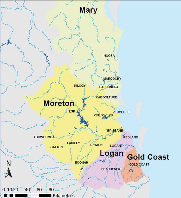
I think that dates from the time the Traveston Dam on the Mary River was still a planned project. Noosa, Maroochy, Caloundra are mostly, I think, supplied from Moreton, Logan almost entirely so.
Here’s a map of the dams:
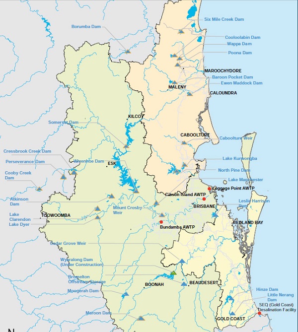
Here’s a map of where the rain fell:
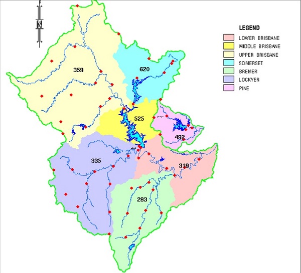
That’s what fell in the rain gauges – nearly 25 inches in the Somerset area. One of the problems was that the engineers found water coming at them in excess of what was shown in the rain gauges. The traditional word is “cloudburst”. One of the cloudbursts was on the Toowoomba Range, which resulted in swift water rescuing in Toowoomba CBD and Grantham being wiped out. Some 150mm (6 inches in the old money) fell in about half an hour, but none fell into a rain gauge. (see Remembering the floods).
That incident was actually part of the Wivenhoe flood event.
This graph shows a profile of Wivenhoe water through the event:
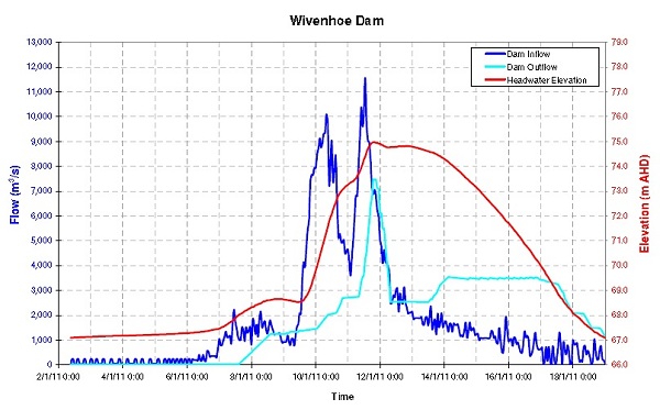
Dark blue is the water coming in. Light blue is the outflow from the dam. The red line is the level of the dam.
At this point I’ll just mention that at 74 metres the focus comes on preserving the dam wall, which if it goes some 244,000 people are in line. The whole event was rated as somewhere between a 1 in 100 to a 1 in 2000 year event, let’s say 1 in 1000 years.
There were at least four major events from Sunday to Tuesday during that January which made up the whole. Have to go to work now. I’ll finish the post with a short summary tonight.
Update
Continuing the story, some facts are in order.
The water storage compartment of Wivenhoe dam is considered 100% full when the water is 67 m on the wall. When it reached that level with more rain forecast the flood management team was assembled, I think on Thursday 6 January. The manual delineates three phases. When the level is above 67 m but not above 68.5 the focus is on keeping the many low-level river crossings open between the dam wall and Moggill, 40 km downriver and near the beginning of the tidal reach. This phase was designated W1 in the manual.
When the dam level is between 68.5 m and 74 m the concern is to minimize urban flooding. The key metric here is a flow of less than 4,000 cumecs (cubic metres per second) at Moggill. Problem is that two of the engineers were aware of the fact that urban flooding started at less than 4,000. Experience has now shown that it begins at around 2,000 cumecs.
This second phase is designated W3 in the manual.
When the level reaches 74 m the concern is to preserve the dam wall. The flood compartment equivalent to 120% of storage is full at 76 m and the wall itself is 80 m. However, the level is never meant to reach 76 m. In case it does and the gates for some reason won’t work, there are three earthen fuse plugs in the auxiliary spillway. The first pops at 75.7 metres, the third at 76.7.
These plugs were installed in 2006 to protect the dam wall. A fourth plug with an extra auxiliary spillway would provide protection for a 1 in 100,000 years event.
In this event the dam peaked at 74.97 m which was 191% capacity. The dam was above 74m from 11am on Tuesday 11 until 6am on Friday 14. The requirement is to bring it back to 67 m within seven days.
This phase is designated as W4 in the manual.
In addition there is a phase W2, which is an optional alternative to W3. It can be skipped at the discretion of the engineers. W2 was absurd, confusing, misleading and impossible to make any sense of. While its origin is unknown to me, W2 appeared to stem from the desire of the people of Lowood to experience water flows that somehow replicated life when the Wivenhoe dam was not there.
Lowwod, a town of around 3,300 people, sits below the dam wall, and just below where Lockyer Creek joins the Brisbane River.
Water takes about 24 hours to flow down the Lockyer from the Toowoomba Range. It takes about 16 hours to flow from Wivenhoe to Moggill. Above Moggill the Bremer River, which flows through Ipswich, joins the Brisbane River. Apart from the Ipswich urban area, most of the urban flooding occurs between Moggill and the Brisbane City reach, where floods are measured by their height at the Port Office. Now remember that the levels at the Port Office, indeed up to Moggill, are affected by the tides.
The Wivenhoe catchment is quite large, and the weather varies from the north, where it reaches just south of Maleny with an average rainfall of 2000 mm to near Toowoomba at the other end, which has an average of just 726 mm. I’m not sure how fine-grained the weather forecasts were then, but even now they can be spotty. Just last week we got 113mm mostly in five hours, whereas about 20 km further south they got nothing.
So the engineers were dealing with a huge dynamic system.
In the 2011 event 2,650 gigalitres of water flowed into the Wivenhoe dam. The comparable figures for 1893 and 1974 would have been 2,740 and 1,410 respectively. In February 1999 there was an event with 1,220 GL that most people don’t remember, because the Wivenhoe had been built and coped with it.
The dam’s water supply capacity is 1,165 gigalitres, or about 2,000 times the daily water consumption of Brisbane. The flood compartment is designed to hold back a further 1,967 gigalitres. So a full dam at 67 metres could swallow up the 1974 flood, a mere 1,410 GL, but not this monster at 2,650 GL.
However, that 1,967 is taken from the current site and is 1.69 times larger than the storage compartment. We were told that back in 2011 the flood compartment was 1.25 times the size of the storage compartment, which would make it 1,456 GL. In the event the dam reached 191% of normal capacity, so the maximum flood water held at any time was 1060 GL.
For perspective 500 GL is known as a ‘sydharb’ – the equivalent of the volume of Sydney Harbour.
So what happened?
In brief, everything was in order until Sunday 9, when the forecast was for the rain depression to move southeast to the Lockyer and Bremer catchments. No doubt the broad strategy was to hold water in the Wivenhoe to wait for water in the Lockyer and Bremer catchments to fall and clear.
Reality proved dramatically different. While there was rain in those catchments, the depression settled over the Upper Brisbane and intensified, yielding three times the forecast for Sunday. On Sunday morning the engineers were talking about millimetres at the Port Office. On Sunday evening the rain intensified, and the Brisbane City Council were ringing up advising that inundation would happen at less than 4,000 cumecs at Moggill.
By early Monday the engineer on duty promised to try to keep Moggill flow to less than 3,500 cumecs, but at that rate urban flooding was inevitable.
Water kept coming, and then at 2pm on Monday we had the ‘cloudburst’ on the Toowoomba Range, where 150 mm (6 inches) fell in half an hour. This flood pulse devastated the Toowoomba CBD, wiped out Grantham below the range and would take 24 hours to reach the Brisbane River. All the while the rain in the Wivenhoe catchment continued, eased, then came again.
On Tuesday 11 at 4pm when decisions were being made to increase the outflows to above the inflows to save the dam wall the forecast was for 75mm in the next 24 hours. Luckily the system weakened and only 12mm arrived.
Unfortunately water backed up badly at the Bremer junction with the Brisbane River, flooding many Ipswich homes and other facilities.
At the Port Office the flood reached 4.6 metres, which you can compare with earlier floods from this 2009 graph:
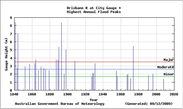
Noteworthy is the number of 19th century floods and five major floods in short order towards the end of the century.
What to make of it all
If you want to fully understand what happened it is necessary to read all three of the earlier posts, plus the comments. At one stage the engineers were dealing with rain of 412mm on one side of the dam and 32mm on the other. They set up a dummy or virtual gauge and ascribed a calculated value to it, which produced a better prediction of the dam level.
At Mt Glorious rain intensity was 68mm/hr which was deemed a greater than 1 in 2000 event. That would yield about 1.6 metres if maintained for 24 hours.
The tide can have an effect up to Colleges Crossing, which is upstream of the Bremer junction.
At comments 12 to 14 on Could the Wivenhoe flood engineers have done better? there is figuring first by me, but then more heavily by John Davidson on what might have been if the engineers had let more water out earlier. In short, major destruction could have been avoided, but there would have still been a minor flood. To take that action would not have avoided inundation, and given with the extended forecast at the time, would have been likely considered foolhardy and certainly actionable if the weather forecast had been correct.
In managing floods, the W2 strategy was at best redundant and should never have been included in the manual. Consideration should be given to abandoning concern for the lower crossings, and focussing on urban damage from the outset. Clearly, I think, consideration should be given to a new bridge to connect Karana Downs, a suburb of Ipswich, to the main highway to Toowoomba. At present Colleges Crossing is one of the first to flood, necessitating cars to use the one-lane Mt Crosby Weir wall, or go the long way around, back through Kenmore to the already congested Centenary Highway, where the Centenary Bridge acts as a choke.
The situation of Lowood should be reviewed. Grantham was rebuilt on higher ground after it was wiped out in the Toowoomba/Lockyer flood.
However, the main concern is the damage done by the lawyers. Are lawyers acting as part of a commission of inquiry exempt from damages claims, or can they wreck professional reputations as they please? My impression is that they can and did.
One outcome is that it is extremely unlikely that any engineer will be willing to manage a Wivenhoe flood ever again. I suspect it will have to be done by bureaucrats who will play very safe, as they are now by deeming it strategic to let 25% of the water storage capacity run into the sea when a rainy season is predicted.
At present there is a tendency to ignore the economic damage that would be wrought by a repeat of the millennium drought.
In August there was an attempt to mediate which failed, so we are up for a 54-day hearing, 10 this year and the remainder in February.
I have sympathy for the victims of the floods, and Anna Bligh said the state would be sympathetic and generous. However, what I’m hearing is testing my sentiments. Clearly we have a bunch of lawyers on the case who will say anything to get a result, trash reputations, tell lies. I think if the authorities have good lawyers and marshal their information well, the action will fail. What we are seeing, however, is not justice, it’s something quite ugly.
Finally, I think there should be special treatment for Hedley Thomas, the ‘investigative’ journalist from the Australian, who made a judgement that the engineers were stupid and negligent, setting the demons loose. No doubt he is well-pleased with the chaos he has created.

Brian wasn’t this all right on the back of near drought conditions where there was a previous concern for water storage levels?
Brian: Thanks for the links back to what you wrote shortly after the 2011 floods, particularly Amazing rain, and what the flood engineers did about it.
I remember doing extensive number crunching after the event and concluding on the basis of 20/20 hindsight that, yes, it would have, in the end, been better if release rates had been higher earlier on. On the other hand, if rainfalls had turned out different the engineers would have been criticized for property damage that could have been avoided if the initial rates had not been so high.
Some of you might like to read the comments made during the discussion including the several of mine. The following was a general comment re the problems of letting lawyers investigate stuff they know little about.
This is the third major disaster inquiry that touched on areas where I have had some relevant experience. In each case my conclusion was that the outcomes were flawed because the inquiries were run by lawyers who had no relevant experience.
The first of these was the Esso Longford gas explosion Two people were killed and Victoria suffered from dramatic gas shortages for quite some time. Basically, the explosion occurred because the temperature in the unit that exploded got below the embrittlement point of the material from which the unit was made. (In other words a design fault – either the unit should have been built from material that would never reach its embrittlement point and/or unit should have been protected by rupture disks that would burst at the appropriate temp/pressure combination and direct the escaping gas to the flare. It is also worth noting that the particular problem hadn’t occurred since the plant started operation 25 years earlier.
So it was a bit startling to see in the papers that one of the main recommendations was that “the control room operators be better trained”. Anyone who has operated a control room when things start to go wrong understands that you cannot depend on the operator realizing how serious what is happening is or the correct response. But this is what the lawyers concluded. (As a matter of interest the operators had been struggling with hydrate build-up all day and probably saw the problem as “keeping the plant running” when problems started in the unit that failed.
The second one was the inquiry into the black Saturday fires. The problems with this inquiry were discussed at length in this LP post The inquiry reinforced the case for having someone other than lawyers running inquiries in areas where they haven’t a clue about who is responsible for what during an emergency and the practicalities of large scale evacuations during bush fires.
Now this one. Miles better than the Black Saturday investigation but, as Desipus put it so well they didn’t understand what the manual was and wasn’t and the relationship between the manual and what the engineers were really supposed to be doing.
At one stage after the flood some of the media were demanding that the engineers be investigated by the crime and misconduct commission.
Which makes you wonder who is going to be willing to run the dam next time there is going to be a major flood event? We could have an enormous stuff up if we have a rigid manual reader who knows she/he will be able to avoid legal attacks by following the manual even if it does seem rather stupid at the time.
John D, thanks for you timely input. I’m going to try to finish the post tonight, but one of my points was going to be exactly:
BilB, I’m not sure what you are saying, but back in 2005, from memory, when we were in the sixth straight year of drought, the dam levels were around 16%, decreasing by about 1% a month, and the dam would be deemed empty when it reached 5%.
When the dam was ‘full’ in January 2011 there was a 120% flood compartment sitting above it. Letting water out of the full dam in the anticipation of rain I think would not have been acceptable to the public at that time.
Brian, in 2007 Brisbane received only 60% of its regular rainfall. The question is how quickly did Brisbane emerge from negative rainfalls to flooding by way of appreciating the underlying thinking on water retention at the time. My recollection from far away was that it was a fairly sudden reversal, but looking at the BOM data, which is not available in one easy to follow format, for Brisbane it wasn’t as sudden as my impression recalls it.
BilB, my memory is not reliable, but I think we got back to 100% in about three leaps finishing in 2010. You can’t really tell from the BOM records. It depends on getting a run of wet weather that lands precisely on the Wivenhoe catchment, which is significantly west of Brisbane.
It takes 50mm to wet the catchment before water runs. Then if you get extra rain on top of that the dam fills quickly. If you leave it two weeks after 50mm or more it needs another 50mm to start the process.
The lawyers, I have just learnt, are making a big thing about an email from a Sunwater engineer in December 2010 saying the public wouldn’t be pleased if they let water out in anticipation of the BOM forecast of a La Nina summer.
He was right. There was nothing in the dam manual at that stage saying you should take the dam below 67m (water storage 100%) in anticipation of a wet summer. At the time the flood compartment of 120% was available (in practice it is a bit less than that – about 95%). The BOM did not predict a specific 1 in 1000 years event.
Now the dam controllers can now reduce it to 75% under those circumstances, which I think is stupid.
I think that the claimants are going for a settlement. I doubt that the state of Queensland is liable, other than as shared social responsibility which would have to come from a disaster levy with cost shared by all.
This situation is an “externality” of the property development industry (just as sulphur is an externality of the coal fired energy industry) and will become a much talked about feature as climate change damage ramps up.
Brian: You said:
All I can say is that the dam operators would be negligent if they did not recognize that Wivenhoe is a key part of both the Brisbane water supply and flood mitigation system. and that the organization needs to be reminded of this from time to time and discuss current priorities.
It is also worth remembering that the W1, W2 etc. settings in the manual should be seen as rough guidelines based on modelling of situations that are inherently fuzzy.
A competent engineering team on the spot should be able to make different decisions on the basis of their modelling of what was actually happening at the time.
I asked my friend, Harry, what his recollection of the Brisbane dam level situation was and his was the same as mine. Right up to the floods there was concern about retaining water for Brisbanes water supply. Its not just that it is raining its also where and for how long.
In Sydney, 2004, we had been having plenty of rain, just non of it fell in the catchment, leaving a level under 40%.
Side comment.
The South Gippsland desal plant near Melbourne was built after several years of low rainfall in the Melbourne dam catchments, with a steady decline in total dam holdings, slowly ratcheted-up water restrictions, public campaigns to persuade folk to conserve water, …. to the point where total dam holdings became a regular report on TV news bulletins.
You may imagine the public pressure in favour of the desalination plant as a stopgap, insurance measure.
Your figure of “under 40%” reminded me of all that, BilB.
I’ve finished the update, just have to proof-read it in the morning.
Revision finished, with some touching up all the way through. I’d like to check what has happened to the four engineers personally and professionally, the current state of the dam manual and what has happened to apparently expand the flood compartment, but I can’t do everything.
Anything that comes out of the “Australian” is stupid and negligent, they work with stupid and negligent coloured glasses, IMHO.